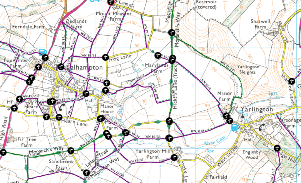
The location of the proposed new farm is bounded by footpaths WN 31/10 “Sleight Lane” which runs to the north and alongside Bluebell Copse, WN 31/9 to the south and WN 22/16 and WN 19/97 “Hicks’s Lane” to the West. The latter forms part of three important named footpaths, the Monarch’s Way, the Leland Trail and the Macmillan Way.
The Monarch’s Way is a 625 mile long distance footpath in England that approximates the escape route taken by King Charles II in 1651 after being defeated in the battle of Worcester. It runs from Worcester to Stratford-Upon-Avon via Bristol and Yeovil to Charmouth and ends at Shoreham, West Sussex. All of the route is waymarked using a logo with a drawing of the ship Surprise above a Prince of Wales three-pointed feathered crown on a silhouette of the Royal Oak Tree which is at Boscobel House, Shropshire. The route is a historically important and popular path across the English landscape.
The Leland Trail is a regional footpath route which runs for 28 miles from King Alfred’s Tower, Penselwood to Ham Hill and follows the trail of John Leland in or about 1535 – 1543. John Leland was a scholar of St. Paul’s School, London and the Universities of Cambridge and Paris. He worked for King Henry VIII as keeper of Royal libraries before 1530 and in 1533 was commissioned to “make a search after England’s antiquities and peruse the libraries of all cathedrals, abbeys, priories, colleges etc. and also all places wherein records, writings and secrets of antiquities were reposed.” During this work, Leland made lists of the information he found and also recorded his journeys from place to place noting ancient buildings, local lore and the character of the countryside. The current trail was conceived in 1986 and work was completed during 1989 after 7 months of intensive efforts erecting 93 stiles, 8 sleeper bridges, 6 traversing bridges, 6 bridleway gates, 31 signposts and 400 waymarks. The trail traverses traditional lowland landscapes of dairy and arable farming and links between beautiful villages and towns in the heart of Somerset. The centre point of the route is Cadbury Castle whose summit offers a spectacular panorama of the South Somerset countryside.
The Macmillan Way runs for 290 miles from Boston in Lincolnshire to Abbotsbury in Dorset passing through Castle Cary. It consists of waymarked paths across beautiful open countryside, after the first 30 miles, following the course of the oolitic limestone belt from South Yorkshire to Dorset. The route was promoted to raise money for the charity Macmillan Cancer Support, a cancer charity originally founded in 1911 by Douglas Macmillan on the death of his father from cancer. Macmillan Way West branches out from the main route at Castle Cary heading west to Barnstaple on the Devon coast for 102 miles making a route across England from Boston to Barnstaple of 346 miles.
Douglas Macmillan (1884 – 1969) was born in Castle Cary and educated at Sexey’s School in Bruton until 1897, then the Quaker Sidcot School Winscombe subsequently Birbeck, University of London. He worked as a civil servant for 40 years, starting in Agriculture and Fisheries and latterly specialising in public health, hygiene and statistics. He founded his charity with the aim to establish what caused cancer and how best to treat it. The charity went through several incarnations before becoming the Macmillan Cancer Support of today, now one of the largest British charities. Specialist health care, information and financial support is provided to people affected by cancer, looking at the social, emotionaland practical impact cancer can have. Macmillan’s link with Castle Cary is marked by a ‘blue plaque’ in the town.
